
The recent brouhaha over the iOS 6 maps app called attention to the strengths of Google Maps. One strong point of Google Maps is its satellite and aerial imagery. That imagery isn’t great everywhere, though. Some geographic areas have images that are less current than others, or that were taken at fairly low resolutions. If you want to be notified when images in a particular area are updated, there’s a website that will do just that.
Follow Your World is a site that lets you input a location, or multiple locations, and be notified when Google updates the satellite or aerial imaging in that location. The screenshot below should give you an idea as to how the app works.
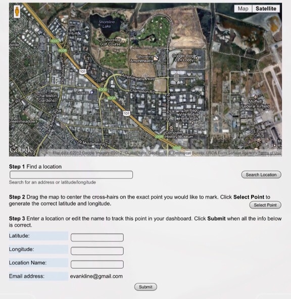
You input an address, or a latitude and longitude, fine tune by dragging the map so your desired location is centered, and then click ‘Select Point.’ If you’re satisfied, click the ‘submit’ button.
The app allows you to submit multiple locations. There’s also a dashboard, from which you can delete locations that you no longer want to monitor.
Is this the type of service that you would use?
Cristian Stan says:
Hi, Evan! I usually check addresses on Google Maps, especially when I have a business meeting and I don’t wanna be late, wandering in the city :D
November 5, 2012 — 11:59 am
Adam says:
Why can’t the images be updated more regularly so that there will be an updated version of the maps at any point in time.
November 5, 2012 — 7:05 pm
Cristian Stan says:
I heard they are still working on the updated version and it won’t be ready any time soon.
November 12, 2012 — 3:11 pm
WilburCohen says:
Recently, not much good apps there. Follow Your World is one of them. Not sure why Google does not update the images regularly, more concerned about how they were able to do this at all possible, especially the latest updates, where there are images of the underwater world.
November 14, 2012 — 4:18 am
Teqlog says:
The florida maps need quite a big overhaul. Google needs to update these soon. Ill be on lookout for my area!
December 28, 2012 — 2:36 pm
Symform says:
Hello Evan! I’ve always relied on the accuracy of Google maps to point me in the right direction. I find myself using Google more than other services. It is very helpful when I can easily find a location and being able to arrive on time.
I was wondering, how often are Google maps updated?
January 4, 2013 — 8:41 pm